Wayfinding Based on Localisation Technologies
Downloads
DOI:
https://doi.org/10.7480/rius.1.196Abstract
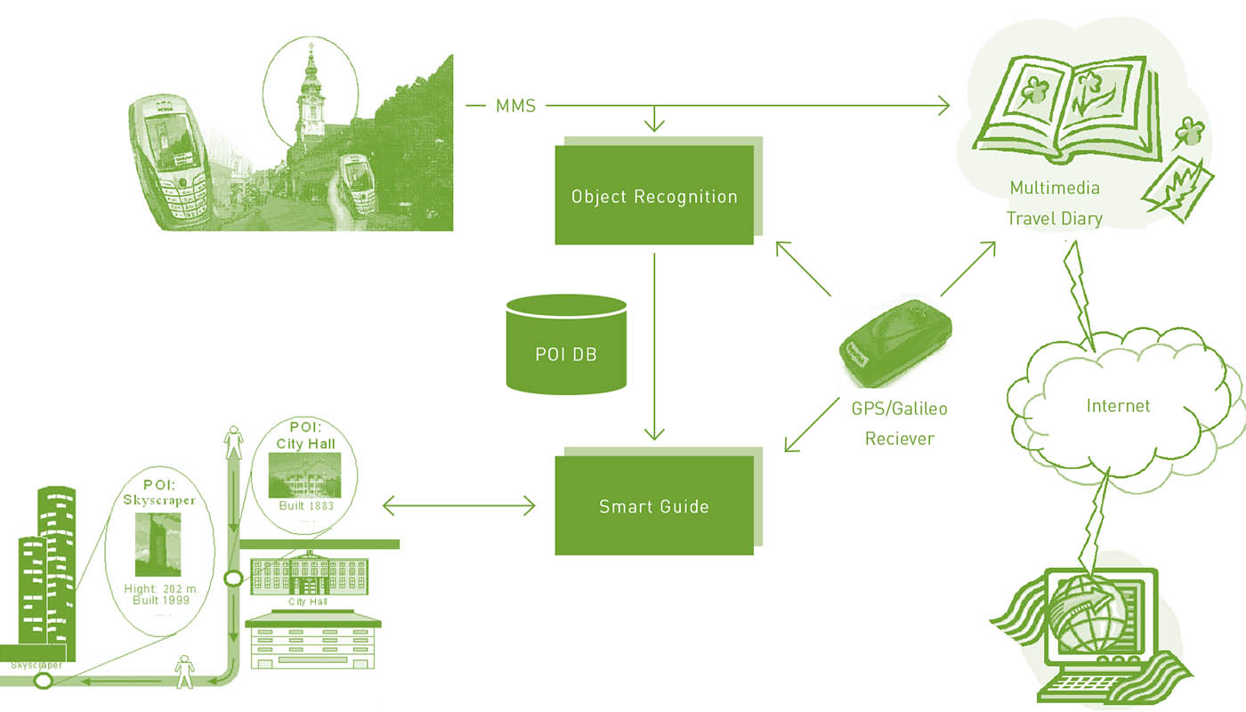
The first part of this paper gives a survey of the state of the art of research on human spatio-temporal behaviour in connection with the development of pedestrian navigation systems. The second part of the paper deals with the problem of pedestrian route choice behaviour. It is in particular concerned with localisation technologies and their adaptation to location-based information systems. The third part of the paper outlines three projects performed at arsenal research and the Vienna University of Technology in these areas. Firstly, it describes a research project on the requirements with regard to the development of ubiquitous cartography for pedestrians in indoor and outdoor environments. secondly, it describes a self-learning travel guide for city tourists based on mobile phones and GPS. Lastly, it describes an audio-guide system which provides landmark-based navigation instruction.
How to Cite
Published
Issue
Section
License
Copyright (c) 2008 Alexandra Millonig, Katja Schechtner

This work is licensed under a Creative Commons Attribution 4.0 International License.
References
Bandini, S., Federici, M.L., Manzoni, S. (2007) A qualitative evaluation of technologies and techniques for data collection on pedestrians and crowded situations, Summer Computer Simulation Conference 2007 (SCSC 07), July 2007, San Diego, California (USA).
Bauer, D., Brändle, N., Seer, S., Pflugfelder, R. (2006) Finding highly frequented paths in video sequences, 18th International Conference on Pattern Recognition (ICPR 2006), August 2006, Hongkong, China.
Blivice, S. (1974) pedestrian route choice: A study of walking to work in munich, Ph.D. Dissertation, University of michigan.
Brändle, N., Bauer, D., Seer, S. (2006) Track-based finding of stopping dedestrians – a practical approach for analyzing a public infrastructure, 9th International IEEE Conference on Intelligent Transportation Systems (ITSC’06), September 2006, Toronto, Canada.
Corona, B., Winter, S. (2001) Datasets for pedestrian navigation services. In: J. Strobl, T. Blaschke, G. Griesebner, eds, Angewandte geographische informationsverarbeitung, Proceedings of the AGiT symposium, Salzburg, Austria, 2001, pp. 84-89.
Daamen, W., Hoogendoorn, S.P. (2003) Research on pedestrian traffic flows in the Netherlands, Proceedings Walk 21 IV, Portland, Oregon, United States: Walk 21 Conference, pp. 101-117.
Gartner, G., Frank, A., Retscher, G. (2004) Pedestrian navigation system in mixed indoor/outdoor environment – The Navio Project. In: M. Schrenk, ed., Proceedings CORP 2004 & Geomultimedia04, Vienna University of Technology, Vienna, Austria, pp. 165-171.
Golledge, R.G. (1995) Defining the criteria used in path selection, technical report UCTC no. 78, University of California Transportation Center.
Helbing, D. (1991) A mathematical model for the behavior of pedestrians, Behavioral Science 36, pp. 298-310.
Helbing, D., Molnár, P., Farkas, I.J., Bolay, K. (2001) Self-organizing pedestrian movement, Environment and Planning B: Planning and Design 2001, 28, 361-383.
Holden, A. (2000) Environment and tourism, Routledge, London.
Millonig, A., Gartner, G. (2007) On defining pedestrian typologies for customised mobile information services, Proceedings of the 4th International Symposium on Location-Based Services & Telecartography, November 2007, Hongkong, China, pp. 388-399.
Millonig, A., Schechtner, K. (2007) Decision loads and route qualities for pedestrians – Key requirements for the design of pedestrian navigation services. In: N. Waldau, P. Gattermann, H. Knoflacher, M. Schreckenberg, eds, Pedestrian and evacuation dynamics 2005, Springer Berlin Heidelberg, pp. 109-118.
Miyazaki, Y. Kamiya, T. (2006) Pedestrian navigation system for mobile phones using panoramic landscape images, SAINT 2006, International Symposium on Applications and the Internet.
Ray M. (2005) Mobile GPS datenerfassung in urbanen gebieten, Diploma thesis, FH Technikum-Wien, Vienna, Austria.
Retscher, G. (2004) Pedestrian navigation systems and location-based services, fifth IEEE International Conference on 3G Mobile Communication Technologies.
Schrom-Feiertag, H., Ray, M. (2007) Learning interests for a personalised city tour based on motion behaviour, Proceedings of the 4th International Symposium on Location-Based Services & Telecartography, November 2007, Hongkong, China, pp. 289-297.
Sefelin, R., Bechinie, M., Müller, R., Seibert-Giller, V., Messner, P., Tscheligi, M. (2005) Landmarks, yes: but which five methods should be used to select optimal landmarks for a landmark- and speech-based guiding system, MobileHCI’05, Salzburg, Austria.
Shoval, N., Isaacson, M. (2007) Tracking tourists in the digital age, Annals of Tourism Research, 34 (1), pp. 141–159.
Thomas, C. (2003) Zu fuss einkaufen. Project report. http://www.fussverkehr.ch/presse/zufuss_schlussbericht.pdf (accessed nov. 2007).
Wiesenhofer, S., Feiertag, H., Ray, M., Paletta, L., Luley, P., Almer, A., Schardt, M., Ringert, J., Beyer, P. (2007) Mobile City Explorer: an innovative GPS and camera phone-based travel assistant for city tourists, lecture notes in Geoinformation and Cartography: Location-Based Services and Telecartography, Springer Berlin Heidelberg, pp. 557-573.