Downloads
DOI:
https://doi.org/10.7480/rius.1.195Abstract
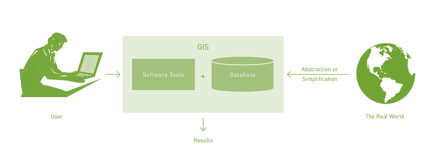
Urban planners and designers depend on spatial-oriented information and knowledge to comprehend a situation and to find design opportunities and solutions for spatial problems. Geographic location, spatial patterns and the distribution of features or events across an urban landscape inform many people of the decisions that planners either make or help others to make. as we will see in this chapter, a Geographic information system (GIS) provides urban planners with a platform on which they can deal with these complex spatial environments and represent, analyse and model them. It also generates new insights through advanced spatial analysis and helps to increase efficiency and flexibility in the planning process.
Parallel to GIS, handheld Global Positioning systems (GPS) are becoming increasingly available, opening the way for various applications in spatial research. The linking up of GPS and GIS in particular has proved to be a powerful instrument for urban analysis. This chapter is an introduction to the use of GPS tracking data in GIS for the descriptive and comparative analysis of pedestrian movement behaviour and the exploration of space-time activity patterns. The first part of the chapter addresses some key concepts of GIS into urban planning and design. It will address a number of fundamental GIS tools for delineation and the analysis of spatial patterns and relationships. The second part elaborates on the analysis of spatial patterns using GIS in combination with GPS. GPS tracking data will be explored by mapping movement and density in order to comprehend and monitor pedestrian behaviour in city centres, with rouen as a case-study.
How to Cite
Published
Issue
Section
License
Copyright (c) 2008 Steffen Nijhuis

This work is licensed under a Creative Commons Attribution 4.0 International License.
References
Alexander, C. [2002) The Nature of Order. An Essay on the Art of Building and The Nature of the Universe, Berkeley, The Center for Environmental Structure.
Batty, M. (2007) Cities and Complexity. Understanding Cities with Cellular Automata, Agent-Based Models, and Fractals, Cambridge, The MIT Press.
Batty, M., Dodge, M., Jiang, B. and Smith, A. (1999) Geographical Information Systems and Urban Design. In: Stillwell, S., Geertman, S. & Openshaw, S., eds, Geographical Information and Planning. Berlin, Heidelberg & New York, Springer-Verlag, pp. 43-65.
Brail, R.K. and Klosterman, R.E. (eds, 2001) Planning Support Systems. Integrating geographic information systems, models
and visualisation tools, Red lands, ESRI Press.
Cross, N. (2006) Designerly Ways of Knowing, London, Springer-Verlag.
Goodchild, M. (1999) Preface. In: Mitchell, A. The ESRI Guide to GIS Analysis. Volume 1, Geographic Patterns & Relationships, Red lands, California, Environmental Systems Research Institute
Hillier, B. (1996) Space is the machine. A configurational theory of architecture, Cambridge, Cambridge University Press.
Hillier, B., Penn, A. Hanson, J., Grajewski, T. and Xu, J. (1993) Natural movement: or, configuration and attraction in urban pedestrian movement, Environment and Planning 8: Planning and Design, 20: 29-66.
Longley, P.A. and Batty, M. (eds, 2003) Advanced Spatial Analysis. The CASA book of GIS, Red lands, Environmental Systems Research Institute.
Lynch, K. (1960) The Image of the City, Cambridge, MIT Press.
Maantay, J. and Ziegler, J. (2006) GIS for the urban environment, Redlands, ESRI Press.
McCoy, J. and Johnston, K. (2002) Using ArcGIS Spatial Analyst, Red lands, California, Environmental Systems Research Institute.
McHarg, I. (1969) Design with Nature, New York, Doubleday.
• Mitchell, A. (1999) The ESRI Guide to GIS Analysis. Volume 7, Geographic Patterns & Relationships, Redlands, California,
Environmental Systems Research Institute.
Mitchell, A. (2005) The ESRI Guide to GIS Analysis. Volume 2, Spatial Measurements & Statistics, Redlands, California, Environmental Systems Research Institute.
Moed, A. (2006) Conversations with Maps. In: Abrams, J. & Hall, P., eds., Else/Where, Mapping. Minneapolis, University of Minnesota Design Institute, pp. 104-125.
Nijhuis, 5. (2007) Permanent architectonic structures and GIS. In: Rosemann, J., ed., Permacity, Delft, Delft University of Technology, pp. 202-209.
Pryor, H. and Wood, J. (2002) http://www.gpsdrawing.com, accessed 16 January 2008.
Ross, R. (2006) Perils of Precision. In: Abrams, J. and Hall, P. (Eds.) Else/Where, Mapping. Minneapolis, University of Minnesota Design Institute, pp. 184-199.
Smith, M.J.D., Goodchild, M.F. & Longley, P.A. (2007) Geospatial Analysis. A Comprehensive Guide to Principles, Techniques and Software Tools, Leicester, Troubador Publishing Ltd.
Spek, S.C. van der (2006) Legible city - walkable city - liveable city. Observation of walking patterns in city centres. In: s.n. (Ed.), Melbourne Walk 21, Proceedings. [pp. 01-10). Melbourne: sn
Spek, S.C. van der (2008) Tracking Pedestrians in Historic City Centres using GPS. In: Van der Hoeven, Smit, Van der Spek (eds) Street-level desires, Delft University of Technology, Urbanism, Delft.
Steenbergen, C. and Aerts, F. (2002) The power of drawing. In: Steenbergen, C., Mihl, H., Reh, W. & Aerts, F. (eds) Architectural Design and Composition, Bussum / Delft, THOTH publishers & Faculty of Architecture TU Delft, pp. 158-177.
Stillwell, 5., Geertman, 5. and Openshaw, 5. (eds, 1999) Geographical Information and Planning, Berlin, Heidelberg & New York, Springer-Verlag.
Turchi, P. (2004) Maps of the imagination: the writer as cartographer, San Antonio, Trinity University Press.
Uum, E. van, and Nijhuis, 5. (2007) Regionaal Plan Stadsregio Arnhem Nijmegen 2005-2020, Nijmegen, Stadsregio Arnhem Nijmegen.