The visual intersection of data as support to decision-making
Downloads
DOI:
https://doi.org/10.7480/rius.4.827Abstract
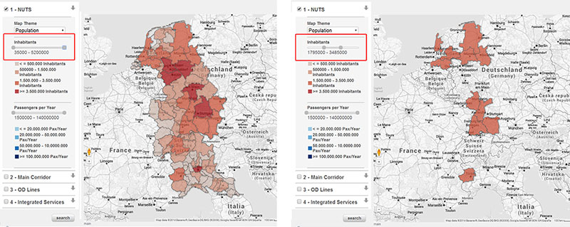
The assessment of spatial systems can be supported by the analysis of data coming from different sources and describing different aspects such as economic, social, environmental, energy, housing or mobility issues. Nevertheless, the analysis of such a large amount of data is difficult. In order to improve the readability of data also with non-technicians, new methods of communication are needed, which could facilitate the sharing of information among people with different skills and backgrounds. In this context, the paper shows the developments in geo-visualisation to support and improve the processes of planning and decision-making. First, the use of a map-based visualisation is suitable for intuitively understanding the location and distribution of specific elements. Second, the graphic interface can be used to drive users in the investigation of data. It can provide a linear method that is more comprehensive to the human mind in dealing with the complexity of spatial systems. In addition, the possibility to select and filter data by single attributes allows databases to be explored interactively and read by differently skilled users. The intersection and overlapping of information enables users to discover the relationships between data, the inefficiencies and critical areas, thus providing suggestions for further reasoning in planning and decision-making. Furthermore, collaborative and participatory sessions require quick answers and simple readability. Thus, the real time response to simple queries widens the opportunities for improving the discussion. A case study describes the methodology used for sharing the data collected during an Interreg IVB NWE Project named “CoDe24” (INTERREG IVB NWE, 2005; ERDF European Territorial Cooperation 2007-2013, 2010). By the use of a web-GIS visualisation tool, namely GISualisation, the project partnership was allowed to explore the data concerning the railways and train typologies along the Genoa-Rotterdam corridor. Despite the high factor of usability of the tool, it was not employed much by participants to the project so that further reasoning is needed to evaluate how digital tools are perceived by professionals.
How to Cite
Published
Issue
Section
License
Copyright (c) 2016 Elena Masala, Stefano Pensa

This work is licensed under a Creative Commons Attribution 4.0 International License.
References
Alexander, C. (1965). A city is not tree. Architectural Forum, 122(1), 58-62.
Allen, P. M., & Sanglier, M. (1981). Urban evolution, self-organization and decision making. Environment and Planning A, 13: 169–183
Arnone, M., Delmastro, T., Endemann, P., Otsuka, N., Pensa, S., & Rosa, A. (2015). Towards an Integrated Railway Network Along the Corridor Genoa-Rotterdam. In H. J. Drewello (Ed.). Berlin: Springer. Forthcoming.
Batty, M. (2003). Planning support systems: technologies that are driving planning. In S. Geertman & J. Stillwell (Eds.), Planning Support Systems in Practice, v-viii.
Batty, M. (2005). Cities and Complexity: Understanding Cities with Cellular Automata, Agent-Based. Cambridge, MA: The MIT Press.
Borges, J. L. (1960). Del rigor de la ciencia. El Hacedor. Buenos Aires: Emecé.
Couclelis, H. (2005). Where has the future gone? Rethinking the role of integrated land-use models in spatial planning. Environment and Planning A, 37(8): 1353–1371.
ERDF European Territorial Cooperation 2007-2013. (2010). Corridor 24 Development Rotterdam-Genoa (CODE24), INTERREG IVB North West Europe Application Form 5th Call. ERDF European Territorial Cooperation 2007-2013.
ETIS plus. (2010). EtisPlus - project summary. Retrieved May 08, 2014, from ETIS plus: http://www.etisplus.eu/
Farinelli, F. (2007). L'invenzione della Terra, Palermo: Sellerio.
Geertman, S. C. M., & Stillwell, J. (Eds.) (2003). Planning Support Systems in Practice. Berlin, Germany: Springer.
Geertman, S. C. M., & Stillwell, J. (Eds.) (2009). Planning Support Systems: New Methods and Best Practice (Advances in Spatial Science). New York: Springer Publishers.
Harris, B., & Batty, M. (1993). Locational models, geographical information and planning support systems. Journal of Planning Education and Research, 12, 84-98.
INTERREG IVB NWE. (2005). CODE24: Corridor 24 Development Rotterdam-Genoa. Retrieved December 10, 2012, from https://www.nweurope.eu/index.php?act=project_detail&id=5504
Isabello, A., Pensa, S., Arnone, M., & Rosa, A. (2013). Reviewing Efficiency and Effectiveness of Interurban Public Transport Services: a Practical Experience. 41st European Transport Conference 2013, ETC 2013, 30 September - 2 October 2013, Frankfurt, Germany. Henley-in-Arden: Association for European Transport (AET). Retrieved January 20, 2014, from AET Papers Repository: http://abstracts.aetransport.org/paper/index/id/237/confid/1
Jacobs, J. (1961). The Death and Life of Great American Cities. New York: Random House. New York: Modern Library, 2011.
Klosterman, R. E. (2012). Simple and complex models. Environment and Planning B: Planning and Design, 39(1), 1-6.
Klosterman, R. E. (1999). The What if? collaborative planning support system. Environment and Planning B: Planning and Design, 26, 393–408.
Klosterman, R. E. (1994). Large-Scale urban models - Retrospect and prospect. Journal of the American Planning Association, 60(1), 3-6.
Landis, J. (2001). CUF, CUF II and CURBA: a family of spatially explicit urban growth and landuse policy simulation models. In R. K. Brail, & R. E. Klosterman (Eds.), Planning Support Systems: Integrating Geographical Information Systems, Models and Visualization Tools (pp. 157-200). Redlands, CA: ESRI Press.
Landis, J. D., Monzon, J. P., Reilly, M., & Cogan, C. (1998). The California Urban and Biodiversity Analysis Model: Theory and Pilot Implementation. Berkeley: UC Berkeley, Institute of Urban and Regional Development.
Latour, B. (1987). Science in Action: How to Follow Scientists and Engineers through Society. Cambridge, MA: Harvard University Press.
Lee, D. B. (1973, May ). Requiem for Large-Scale Models. AIP Journal, 163-77.
Pensa, S., & Masala, E. (2014). InViTo: An Interactive Visualisation Tool to Support Spatial Decision Processes. In N. N.
Pinto, J. A. Tenedorio, A. P. Antunes, & J. R. Cladera (Eds.), Technologies for Urban and Spatial Planning: Virtual Cities and Territories (pp. 135-153). Hershey, PA: IGI Global Book.
Pensa, S., Masala, E., & Lami, I. M. (2013). Supporting planning processes by the use of dynamic visualisation. In S. Geertman, F. Toppen, & J. Stillwell (Eds.), Planning Support Systems for Sustainable Urban Development (Vol. 195, pp. 451-467). Berlin Heidelberg: Springer.
Pensa, S., Masala, E., Arnone, M., & Rosa, A. (2014). Planning local public transport: a visual support to decision-making. Procedia - Social and Behavioral Sciences, 111, 596-603.
Portugali, J. (2011). Complexity Cognition and the City. Berlin: Springer Heidelberg.
Portugali, J., Meyer, H., Stolk, E., & Tan, E. (Eds.) (2012). Complexity Theories of Cities Have Come of Age. Berlin Heidelberg: Springer.
te Brömmelstroet, M. C. (2010). Equip the warrior instead of manning the equipment: Land use and transport planning support in the Netherlands. Journal of Transport and Land Use, 3, 25-41.
Uran, O., & Janssen, R. (2003). Why are spatial decision support systems not used? Some experiences from the Netherlands. Computers, Environment and Urban Systems, 27, 511-526.
Vonk, G. (2006). Improving planning support; the use of planning support systems for spatial planning. Utrecht: Nederlandse Geografische Studies.
Vonk, G., Geertman, S., Schot, P. (2005). Bottlenecks blocking widespread usage of planning support systems. Environment and Planning A, 37(5): 909–924.
Waddell, P. (2000). A behavioral simulation model for metropolitan policy analysis and planning: residential location and housing market components of UrbanSim. Environment and Planning B: Planning and Design, 27(2), 247-263.
Waddell, P., Borning, A., Noth, M., Freier, N., Becke, M., & Ulfarsson, G. (2003). Microsimulation of Urban Development and Location Choices: Design and Implementation of UrbanSim. Netherlands: Springer.
Wegener, M. (1994). Operational Urban Models State of the Art. Journal of the American Planning Association, 60(1), 17-29.
Wegener, M. (1995). Current and Future Land Use Models. Land Use Model Conference. Dallas: Texas Transportation Institute.
White, R., & Engelen, G. (1997). Cellular automata as the basis of integrated dynamic regional modelling. Environment and Planning B: Planning and Design, 24, 235-246.
White, R., & Engelen, G. (2000). High-resolution integrated modelling of the spatial dynamics of urban and regional systems. Computers, Environment and Urban Systems, 24, 383-400.
Wolfram, S. (1984). Cellular automata as model of complexity. Nature, 311, 419-424.