Downloads
DOI:
https://doi.org/10.7480/rius.4.854Abstract
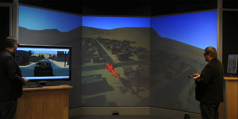
Geodesign requires the visualization of concepts and ideas within a context of geo-information of the respective place in a way that is understandable to people with different backgrounds – planners, geographers, architects, but also the users or inhabitants of the place. All of the roles involved have different requirements and need different information to fulfil their tasks within the geodesign process. In this contribution, we present the structure of a software system combining a GIS, a simulation system and a VR component, as well as interfaces to different interaction devices (like a GPS receiver, a spacemouse, multi-screen projection systems or devices for haptic feedback). This enables simulations of the place in its geographical context, as well as immersive presentations that are understandable regardless of the knowledge of a plan’s symbolic language. All this happens without the need to convert frequently between the software tools that are commonly used by the different roles.
How to Cite
Published
Issue
Section
License
Copyright (c) 2016 Juergen Rossmann, Arno Buecken, Martin Hoppen, Marc Priggemeyer

This work is licensed under a Creative Commons Attribution 4.0 International License.
References
DIN – German Institute for Standardization (2004). DIN EN 13814: Fairground and amusement park ma-chinery and structures – Safety; German version EN 13814:2004. Beuth-Verlag.
Grant, P. R., & Reid, L. D. (1997). Motion washout filter tuning: Rules and requirements. Journal of Aircraft, 34(2), 145-151.
Hildebrand, D. (1992, April). An Architectural Overview of QNX. In USENIX Workshop on Microkernels and Other Kernel Architectures (pp. 113-126).
Hoppen, M., Rossmann, J., Schluse, M., & Waspe, R. (2010). A New Method For Interfacing 3D Simulation Systems And Object-Oriented Geo Data Sources. In T. Kolbe, G. König, & C. Nagel (Eds.), The 5th Inter-national Conference on 3D Geoinformation ISPRS 2010 (pp. 51-56). Aachen, Germany: Shaker Verlag.
Hoppen, M., Schluse, M., Rossmann, J., & Weitzig, B. (2012). Database-Driven Distributed 3D Simulation. Proceedings of the 2012 Winter Simulation Conference (pp. 1-12).
Hoppen, M., Waspe, R., Rast, M., & Rossmann, J. (2014). Distributed Information Processing and Render-ing for 3D Simulation Applications. International Journal of Computer Theory and Engineering (IJCTE), 6(3), 247-253.
Jensen, C. S., Dyreson, C. E., Böhlen, M., Clifford, J., Elmasri, R., Gadia, S. K., et al. (1998). The consensus glossary of temporal database concepts—february 1998 version. In Temporal Databases: Research and Practice (pp. 367-405). Berlin-Heidelberg, Germany: Springer.
Jung, T. J., Rast, M., Kaigom, E. G., & Rossmann, J. (2011, January). Fast VR Application Development Based on Versatile Rigid Multi-Body Dynamics Simulation. In ASME 2011 International Design Engineering Technical Conferences and Computers and Information in Engineering Conference (pp. 1481-1490). American Society of Mechanical Engineers.
Kolbe, T. H., Gröger, G., & Plümer, L. (2005). CityGML: Interoperable access to 3D city models. In Geo-in-formation for disaster management (pp. 883-899). Berlin-Heidelberg: Springer.
Krämer, M. A. (2004). Universelle Fahrzeugsteuerung als integrativer Bestandteil einer VR-Simulations-plattform. Shaker Publishing.
Rossmann, J., Jung, T. J., & Rast, M. (2010, October). Developing virtual testbeds for mobile robotic appli-cations in the woods and on the moon. In Intelligent Robots and Systems (IROS), 2010 IEEE/RSJ Inter-national Conference on (pp. 4952-4957). IEEE.
Steinitz, C. (2012). A Framework for Geodesign – Changing Geography by Design. Redlands, CA: Esri Press.
Telban Robert, J., & Cardullo, F. M. (2005). Motion Cueing Algorithm Development: Human-Centered Lin-ear and Nonlinear Approaches. NASA/CR-2005-213747.
Zacharias, G. L. (1978). Motion cue models for pilot-vehicle analysis. Bolt Beranek and Newman inc. Cam-bridge MA Control Systems Dept.